Date of hike: Tues. July 26, 2011
Section: 15--from its most northerly end; its termination point at 12.3 km
Section: 15--from its most northerly end; its termination point at 12.3 km
Weather: 26C, low humidity, partly cloudy and breezy
Duration of hike (including a brief rest stop part-way): 2 hours 40 minutes
Distance: 10 km
So, now that the reasons behind this venture have been explained, let’s explore our first hike out. But before getting into the details of that, a few housekeeping things need to be taken care of....
Once we decided that we wanted to do this “end and back” project, we definitely needed to get the TVT maps. The Bruce Trail Association offers a download service, where you can purchase individual trail maps for each section, if you so wish. The Thames Valley Trail Association does not offer this, so I headed to Novack’s to buy a trail map book for $25. A sound investment indeed!
We decided to start at the “end” in St. Mary’s, as opposed to the “start” in Talbotville because it’s a little closer to our home when heading out for the day (at least for the time being). That required us to check out Map 6, the last map, and get our bearings. After checking the web site for any trail re-route information, we were ready for the first leg of our journey. We drove to St. Mary’s and parked in the lot across from the quarry pool and beside some tennis courts—directions for all of this are included in the trail guide so it wasn’t difficult.
The end of the TVT is actually the beginning of the Avon Trail which continues from St. Mary’s to Conestoga, linking into the Grand Valley Trail....wow! You could just keep on going! However, we’ll pass on that for the time being and stay focused on our original goal!
 |
| Highlighted area shows where we began on Map 6 (bottom right corner), to the slashed area slightly above....5 km one way. |
Now that those little details have been taken care of, on to the first leg of our quest....
After touching the rock marking the end of the trail, we headed off, following the white blazes.
The first couple of kilometres were not particularly exciting. Considering that we headed back Perth Road 123, from whence we came, and were passed by several large trucks heading back and forth from the St. Mary’s Cement plant, it really wasn’t anything special at all.
But then we turned off of the road and down a lane way toward the Thames River.
As we entered a wooded trail, it did not seem that many other hikers had actually been this way or at least not too recently. The trail was overgrown and it was sometimes difficult to see the blazes. The surface of the path was on a steep hill side as well, making the footing even more precarious.
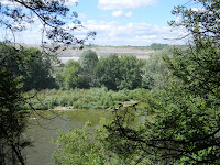
But we trudged along, glancing through the trees and catching a glimpse of the river every so often. There were a few gullies to traverse, but with the recent dry spell, there were no worries about getting our feet wet.
If it hadn’t been for the greenery and the challenge of the course, it would not have been very pleasant hike due to the noise of the trucks across the river in the quarry.
With the breeze that was blowing that day, a fine dust had settled on the leaves of the trees and I noticed that my plastic covered map was feeling a bit gritty to touch.
But soon we had passed far enough along and the noise disappeared and the air was clearer as well.
At about the same time, the path headed down closer to the river’s level and things became even greener as it had a better water supply, in spite of the brief drought we’d been experiencing. There were some lush green groves, blanketed with small groundcover growth and the trees were cathedral-like as the sunlight shone through them.
A few times, we came out to the edge of a field and could see off on the horizon, the barn or the homestead. It reminded us of the generosity of many farm owners in allowing something like the TVT to pass through their property.
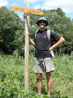
We had picked a turn-around point that was about 5 km out. This particular point had a path that lead back to a county road where there was parking. Thinking that we might start from this point next time when we resume our hike, we thought this was a logical spot to choose for this. At first, we weren’t sure whether we would be able to easily identify this spot, but as you can see, we had no reason to worry as the TVT volunteers had placed a sign post with directions and distances.
So back we went as we came. Returning was much easier as we were familiar with the landmarks and terrain. We took our time to stop a bit more, enjoying the river scenery and to have a little rest and snack.
 Even so, we made excellent time back, returning about 10 minutes faster than what we had gone out. It wasn’t a terribly hot day...but we had worked up a good sweat and our only regret was that we had not thought to bring towels and swim suits to take a dip in the famous St. Mary’s quarry.
After touching the rock upon our return, we had officially completed the first leg of our “end and back” TVT project. Ten kilometres down....only 250 to go!


No comments:
Post a Comment