Tuesday, June 26, 2012

Deadline Looming!

Date of hike:  Sun.  June 24, 2012
Weather: 27C (humidex of 29C); partly cloudy and overcast at times                                                                                       
Duration of hike:  2 hours 32 minutes

Section:  3—from Delaware Conservation Area parking lot to the boundary of the old Delaware Dump and Miller Road (4.3 km mark)

Distance:  7.4 km              Cumulative distance:  180.3 km

After a six week reprieve, we were just itching to get out on the trail again.  It had been a busy month for both of us, but if we are to complete the full trail, end and back, within a 12 month time period, then we best get back to business!  The Thames Valley Trail Association offers a badge to those who complete the full distance, end to end, within this designated time frame.  We, however, are doing twice the distance; so while it does pose a greater challenge, it isn’t anything that is unachievable.  Nevertheless, we have only slightly more than one month to finish this baby off!  It really isn’t about the badge, but the significance of the feat.
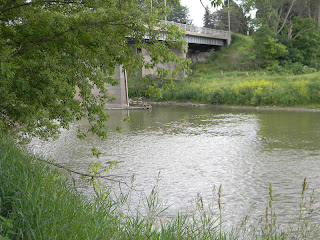
Highway 2 bridge over the Thames--looking from
the north side.

Leaving from the Delaware Conservation Area parking lot, the trail seemed to be fairly obvious.  But hikers be forewarned…..if travelling south along the path, don’t miss this crucial turn! 
The trail blazes are on rocks beneath
the bridge--to the left of the bridge buttress.
Shortly after heading out, the route passes beneath the Highway 2 bridge that goes over the Thames River.  Without paying close attention to the trail guide directions, we continued along the river’s edge instead of diverting away from it.  The trail blaze was down low, instead of high, so we easily missed it.  After a short time of trying to navigate our way through tall grass and weeds, we realized that something was amiss and turned back.  
You know you've gone the right way when you
see the remains of the old bridge buttress--where the
highway used to go before road improvements were made.
Checking the trail guide, we saw that we actually needed to go away from the river and along a quiet side street in the village of Delaware, before heading back onto a wooded trail.  Our "getting lost", added a little bit of extra time and distance to this excursion, but nothing too significant.  Lesson to be learned…..always keep a sharp eye open for the trail blazes….if none are in view, then you are probably off course!
Heading down a wooded path--we were
in for a treat!
This section of the trail was a veritable wildlife paradise.  The tree cover was dense and the plant life was lush. 

Another oxbow lake was tucked away, hidden from any human influence, giving the birds, animals, and aquatic life their own private sanctuary. 
 As well, the trail traversed a steep bluff that required many up and down climbs.  It made for an interesting and challenging trek, to say the least.  Trail volunteers have made this section a bit easier though, with their built-in steps, bridges, and culverts over wet spots and ravines.
A steep climb, heading up and out
of the trail--toward the trail re-route.
A trail re-route occurs along this section as well.  One need not worry about missing this re-direction though.  It was well marked and easy to find.  I had printed off the re-route directions from the TV Trail web-site, but found them to be somewhat confusing as there seemed to be two different sets of directions.  To simplify, just follow the blazes up the bluff that goes along the fenced edge of Highway 402. 
This takes you to Miller Road, which passes over the 402 and toward a dead end that once lead to the entrance of the Delaware Dump.  The dump is now closed, but you can still see some signs of stray debris lying about.  However, as you walk along the old border of the dump, you re-connect with the trail as it returns to the Thames.
 We made this our turn around point for this trip and stopped here for a short refreshment break.
Our view while we stopped for a little break.
With the approach of the lazy days of summer, we can hopefully complete what remains of the trail, before July 26.  That date marks the one year anniversary of when we began this adventure.  In fact, we will need to get it all done before we leave on holidays, just prior to that date.  So here’s looking forward to the home stretch!
Paul, sampling some of the wild raspberries that
grow along the trail.
Stopping to smell the tiger lillies.
Colourful graffiti under Highway 2
bridge--can't show you all of it--too many
#$**##*! expletives!

Saturday, June 09, 2012

Delaware Outpost

Date of hike:  Sun. May 13 2012

Weather: 21C; bright sunshine and a clear blue sky                                                                                         

Duration of hike:  1 hour 28 minutes

Section:  4—from west side of Komoka Rd. bridge to Delaware Conservation Area parking lot

Distance:  6.0 km              Cumulative distance:  172.9 km

Picking up from where we left off at the Komoka Road bridge, this was another little stretch that had to follow the road.  It’s nice to keep sections like these on the short side.  After all, hiking long distances along the roadway doesn’t feel all that adventurous and it seems to deflate the attraction of wilderness pathways that could follow.  So we made quick work of this section, making only brief stops to take the odd photo.

 As we made our way south east on Gideon Drive, we soon came into the village of Delaware.  The original settlement was further west of where it stands now; where Belvoir Farms is located today.  We took a few moments to read some historical plaques that are erected in the town and learned about its founder, Gideon Tiffany.


This section of the TV Trail crosses paths with the “Southwest Ontario Barn Quilt Trail”.  Coming into Delaware along Gideon Drive, you will see two of these murals mounted on the sides of barns and one other on free-standing posts by the church. 
This is a relatively new quilt, recently put up--hence
its name is not available on the Barn Quilt web-site.
But it's located on the grounds of the church in Delaware.
Next Door Neighbour--symbolizing the
isolation of the pioneer life, while living
along the Thames.
Thames River--commemorating the Canadian Heritage
River designation of the Thames.
If you continue to travel east on Highway 2 (which is a right turn off of Gideon Drive as you pass through Delaware), you’ll see several more of these panels along the roadway.  These panels are part of a large community project to highlight the rich history of the area.  Each one tells a story about its location and can be found not just in Middlesex County, but in Brant, Elgin, Norfolk, and Oxford counties as well.  Hundreds of volunteers, including quilters and historians, have worked together to produce these stunningly visual pieces of artwork.

That brings me to elaborate on the history that this area possesses, especially with regards to the War of 1812.  Delaware itself was an established British outpost during this time and not far from here, the “Battle of the Thames” (also known as the Battle of Moraviantown) took place.  It was in this particular battle that Chief Tecumseh gave his life while unsuccessfully fighting off the American invaders.  The “Battle of Longwoods” was another significant milestone of this war that took place along the banks of the Thames. 
While the TV Trail starts to veer away from the Thames River, just after passing through Delaware, I think it would be a great idea to continue its course along the Thames, taking in some of these historical monuments.  Maybe even following it all the way to its mouth into Lake St. Clair!  But that would require a huge undertaking of many dedicated volunteers….maybe someday!
Turn around point--Delaware Conservation Area


Red-winged blackbird sitting on a post.

Sunday, May 27, 2012

The 100 km Countdown

Date of hike:  Sun. May 6, 2012

Weather: 17C at start; 22C at completion; bright sunshine with a light breeze                                                                                     
Duration of hike:  3 hours 44 minutes  (including a 15 minute stop for lunch)

Section:  5—from Oxford St. entrance of Komoka Provincial Park to entrance of park on Gideon Dr.
                4—from entrance to Komoka Prov. Park on Gideon Dr. to west side of Komoka Rd. bridge

Distance:  13.4 km            Cumulative distance:  166.9 km
We could not have picked a better day to hike this section that passes through Komoka Provincial Park.  Bright sunshine, gentle spring breezes, and wild flowers blooming everywhere were just the beginning of all good things that could be said of this day on the trail. 


Fiddleheads anyone?
Hiking this section was not a new experience for either of us though, having been through these trails many times before on a Sunday hike with the kids.
Komoka Provincial Park is a small park with few amenities; it’s nothing like the Pinery where one can camp and enjoy a variety of activities and services that are provided.  There isn’t an entrance fee that must be paid in order to get in.  Just pull up to one of the parking areas that offer access in, pick a trail and off you go! 
Hiking is its main raison d’etre and that was certainly the case on this sunny Sunday as we passed numerous groups of hikers of all types….especially families with young children.   This is a great spot to take kids out for an outdoor expedition as the trails offer easy hiking, but with lots of nature bonuses!
Butterflies enjoying the nectar in
the honeysuckle.

Small marsh located along the trail.

Carp sunning themselves just upstream from
the fisherman's hooks!
Turkey vultures circling overhead.


There is the main trail that traverses the park from east to west; that’s the Thames Valley Trail and it’s marked with the traditional white blazes.  But from the main trail, you can choose to loop around and head off onto the Blue, Yellow, or Orange trails.  A good spot to start is at the main Gideon Drive parking lot, hike toward the river on the Blue trail then switch over to one of the other trails to complete a circuit.
Yellow trail marker
Orange trail marker
Blue trail marker--many of the white
TV Trail blazes are metal strips in
Komoka Park.
As the trail passes through the park, we crossed many deep ravines, all with the aid of bridges that had been built.  The path wound its way up the bluff, giving us some great views of the river, and then back down to its edge. 


We exited the park at its west entrance on Gideon Drive, then continued down the road for a bit, avoiding some private land, before turning back onto a path that went alongside of the river.  We followed this until it went under the Komoka Road bridge and came back up toward Gideon Drive.  This was our turn around point for this chapter of our adventure.
This downed tree blocked the path
where the trail crossed onto private
land, just before the
Komoka Road Bridge

Turn around point--telephone pole that
is just west of the bridge.
Completing this section now brings our cumulative kilometre total to 166, meaning that we have less than 100 km to go in completing our end-and-back adventure.  It won’t be long now!
The view from our lunch time stop
Our lunch time stop
One of the many ravines that cut through Komoka Park.